How Drones Help Detect Sinkhole Causes Before Damage Happens
Posted by Adam John
Filed in Technology 21 views
Sinkholes are a serious problem in many parts of the United States. They can damage roads, homes, farms, and buildings without much warning. A sinkhole forms when the ground below the surface becomes weak and collapses. In recent years, drone technology has become a powerful tool to study land conditions and detect sinkhole risks early.
At Zena Drone, advanced drones are used to survey land, collect data, and help experts understand sinkhole causes before they turn into dangerous ground collapse. This article explains what sinkholes are, why they happen, and how drones play an important role in sinkhole detection and prevention.
What Is a Sinkhole?
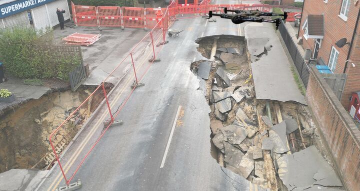
A sinkhole is a hole or depression that forms when the ground can no longer support the surface above it. Sinkholes may appear slowly over time or suddenly collapse without warning. Some are small and harmless, while others are large enough to swallow roads, vehicles, or homes.
Sinkholes can happen in cities, suburbs, and rural areas. They often form in places where water interacts with certain types of rock underground.
Understanding Sinkhole Causes
To understand how drones help, it is important to first understand sinkhole causes. Most sinkholes are linked to natural processes, human activities, or a mix of both.
1. Weak Rock Below the Ground
One of the most common sinkhole causes is the presence of soft rock like limestone, gypsum, or salt beneath the soil. These rocks slowly dissolve when exposed to water. Over time, empty spaces form underground.
As these spaces grow larger, the ground above them becomes unstable. When it can no longer hold its weight, a sinkhole forms. States like Florida, Texas, Kentucky, and Tennessee are especially at risk because they have large areas of limestone bedrock.
2. Water Erosion Underground
Water is one of the biggest factors in sinkhole formation. Rainwater moves through the soil and carries small particles with it. This process slowly washes soil into cracks and cavities underground.
Heavy rainfall, flooding, or long wet seasons can speed up erosion. When too much soil is removed, the surface may collapse.
3. Drought and Sudden Rain
Drought conditions can also increase sinkhole risk. When groundwater levels drop during dry periods, underground support weakens. If heavy rain follows the drought, water rushes into dry spaces quickly.
This sudden change is one of the lesser-known sinkhole causes but is becoming more common due to changing weather patterns.
4. Human Activities
Human actions can greatly increase the risk of sinkholes.
-
Construction adds weight to weak ground
-
Broken water or sewer pipes wash soil away
-
Mining and drilling leave empty underground spaces
-
Excessive groundwater pumping lowers water support
Many sinkholes in urban areas are linked to human activity rather than natural causes.
Why Sinkholes Are Hard to Detect
One of the biggest challenges with sinkholes is that most of the damage happens underground. The surface may look normal until collapse occurs.
Traditional inspection methods often require ground crews, drilling, or heavy equipment. These methods can be slow, costly, and limited in coverage. This is where drones offer a safer and faster solution.
How Drones Help Identify Sinkhole Causes
Drone technology has changed how land inspections are done. At Zena Drone, aerial drones are used to monitor terrain, detect changes, and collect high-quality data.
1. Aerial Land Surveys
Drones can fly over large areas quickly and capture high-resolution images of the ground. These images help identify:
-
Small ground depressions
-
Changes in land shape
-
Cracks or sinking areas
-
Poor drainage patterns
Early surface changes often point to deeper sinkhole causes.
2. Thermal and Multispectral Imaging
Advanced drones can carry thermal and multispectral cameras. These sensors detect moisture levels and temperature changes below the surface.
Areas with abnormal moisture patterns may indicate underground erosion or leaking pipes. This data helps experts locate high-risk zones before collapse happens.
3. 3D Mapping and Terrain Models
Drone mapping software creates detailed 3D models of the land. These models allow engineers to measure small changes in elevation over time.
Even minor sinking can signal early sinkhole development. Regular drone surveys make it easier to track changes and spot problems early.
4. Safer Inspections
Inspecting unstable land can be dangerous for people. Drones allow inspections without putting workers at risk.
They can safely survey roads, construction sites, farms, and residential areas where sinkholes may form.
Drone Use in Sinkhole-Prone Areas
In states like Florida and Texas, drones are now widely used for:
-
Infrastructure inspection
-
Road and bridge monitoring
-
Construction site planning
-
Environmental studies
-
Emergency response
Zena Drone supports these efforts by providing reliable aerial data that helps professionals understand sinkhole causes and reduce damage.
Benefits of Using Drones for Sinkhole Detection
Using drones offers many advantages:
-
Faster inspections
-
Lower costs
-
Wide area coverage
-
High accuracy
-
Reduced human risk
These benefits make drones an important tool for modern land assessment.
Preventing Sinkhole Damage with Drone Data
While sinkholes cannot always be prevented, drone data helps reduce risk. Early detection allows:
-
Better land planning
-
Timely repairs of leaks
-
Smarter construction decisions
-
Improved public safety
When sinkhole causes are identified early, damage can often be minimized.
The Role of Zena Drone
Zena Drone focuses on advanced drone solutions for inspection, monitoring, and data collection. By using modern drone technology, Zena Drone helps industries and communities better understand land conditions and hidden ground risks.
Drone-based monitoring is becoming an essential part of managing sinkhole risks in the United States.
Final Thoughts
Sinkholes are a serious natural and human-related hazard. Most sinkhole causes involve weak rock, water movement, or changes beneath the ground. Because these changes are often hidden, early detection is difficult.
Drones provide a smart, safe, and efficient way to detect early warning signs from above. With tools like aerial surveys, thermal imaging, and 3D mapping, drone technology is changing how sinkhole risks are managed. As sinkhole risks grow, drone-based solutions from companies like Zena Drone are helping protect land, property, and lives.